Introduction
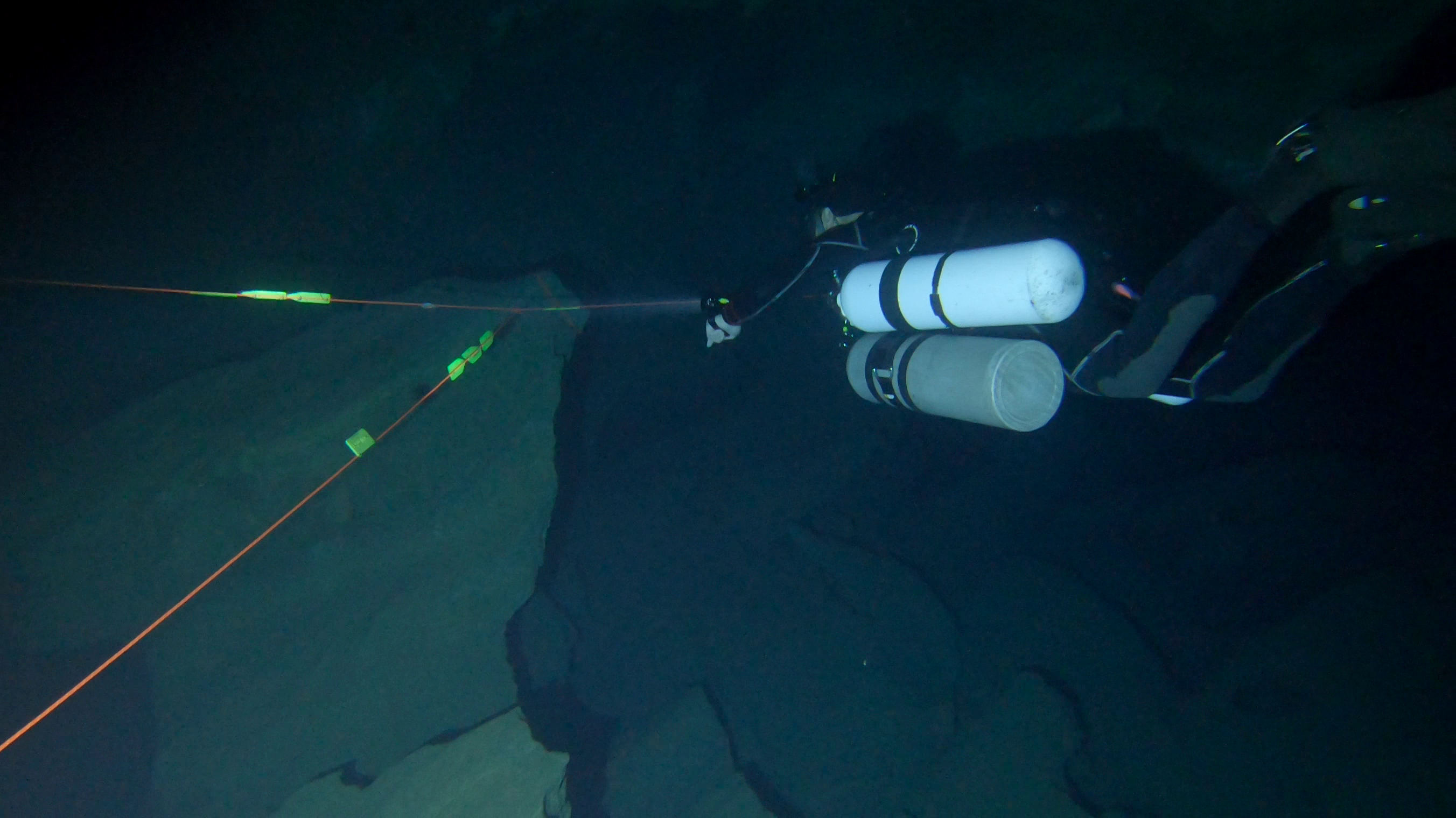
In my previous writings, I’ve mentioned my habit of mapping the galleries when I visit Cueva del Agua in Murcia. My goal is to explore increasingly challenging areas to continue improving the process. In my last expedition, my intention was to delve into the 600-meter labyrinth, known for being the section with the highest number of topographic pools throughout the cave’s extent, just before the 850-meter stretch. However, I encountered an issue: my vehicle, the scooter, is quite old and has problems with water ingress. Therefore, my focus shifted, and I decided to thoroughly traverse all the installed lines in the cave, carrying out the topography process. Unfortunately, due to percolation and the conditions created by my own presence, turbid water hindered my vision, preventing me from clearly seeing the template used for mapping.
The topography
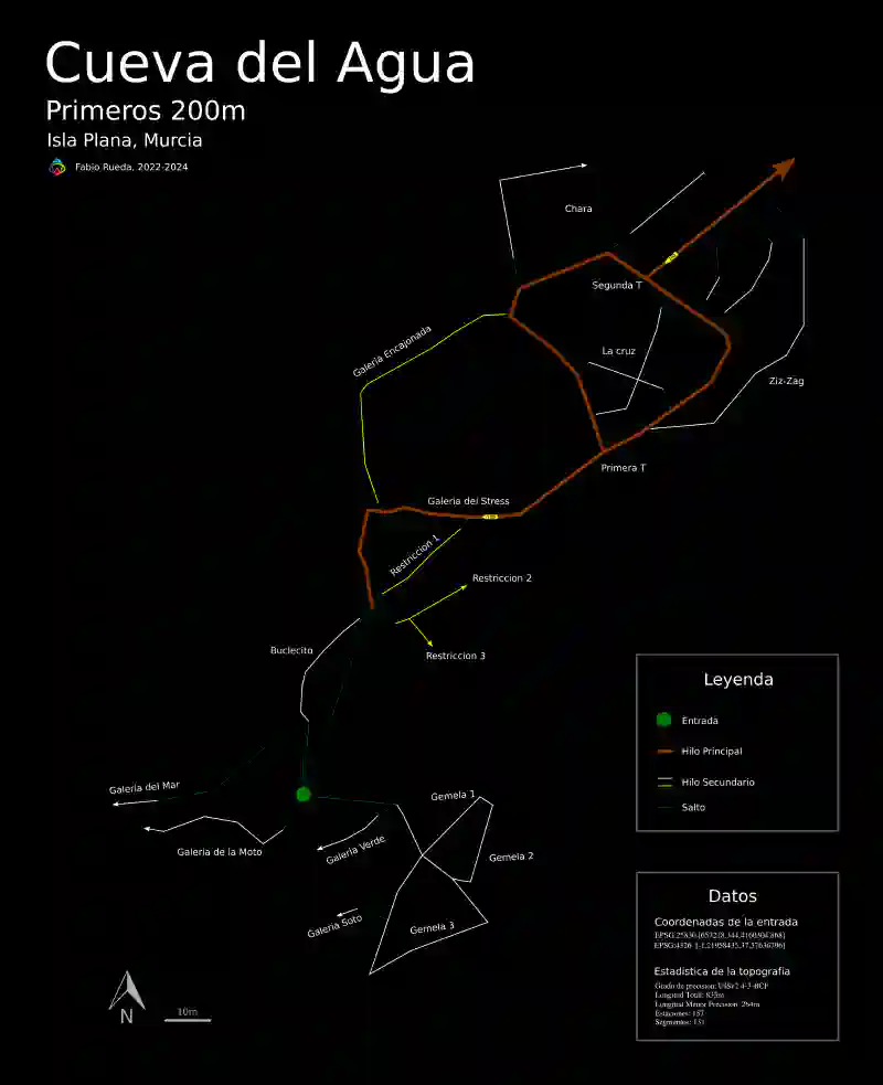
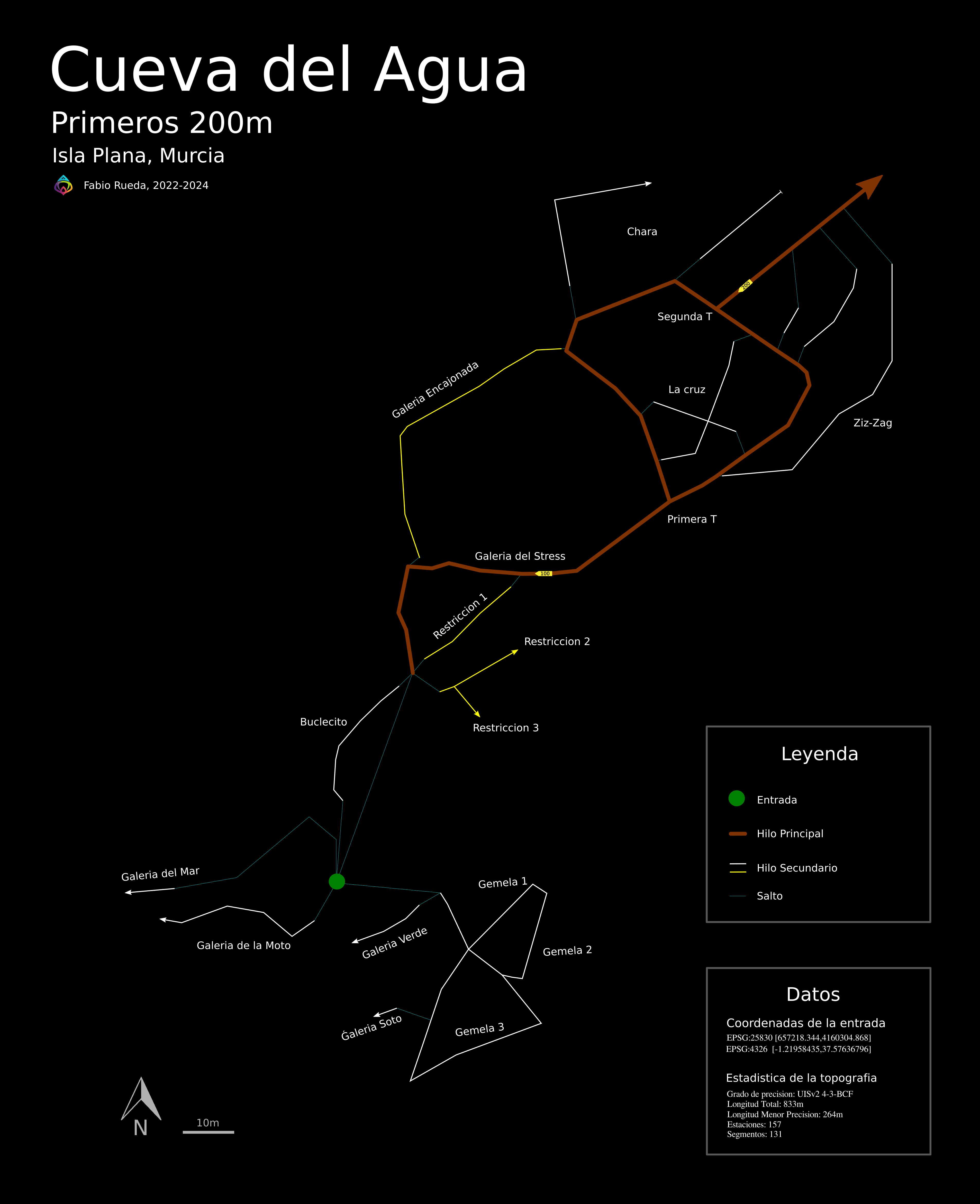
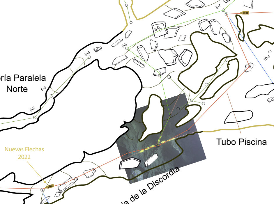
The original topography has a black background to enhance the cave’s natural colors. Additionally, I’ve created an alternative version with a white background and complementary colors to facilitate printing.
Key Features of the Map
I proceeded to cartographically trace the cave’s route in its state at the time of the topography’s publication, indicating the corresponding date. In the map, each segment of this route is represented by a color code reflecting the tonality present in the cave. The main line, marked in orange and meticulously established by the exploration group, has been drawn with a thicker stroke, while the secondary lines are represented with thinner strokes in white or yellow, depending on their chromatic correspondence in the cave. The non-installed segments, identified as jumps, are outlined with finer strokes and in blue to highlight their nature as potential routes that are not physically present but are useful for planning cave itineraries and calculating necessary equipment such as spools and cookies.
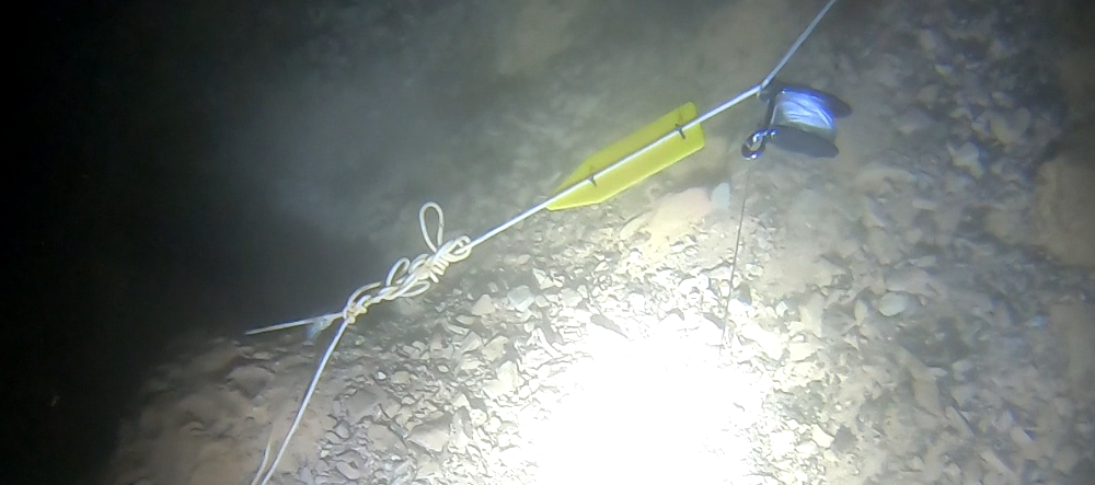
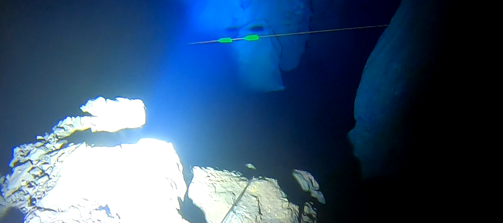
The map also features reference marks every 100 meters and 200 meters, visible to the diver underwater, represented by a directional arrow. Additionally, a schematic point indicating the entrance, represented not by the pool but by the first characteristic rock formation in the shape of a Y, is included, found at an approximate depth of 6 to 7 meters upon entering the cave.
The segments outlined in thin blue strokes, as mentioned earlier, correspond to topographic sections of my own exploration that have been uninstalled and serve only as jump indicators on the line.
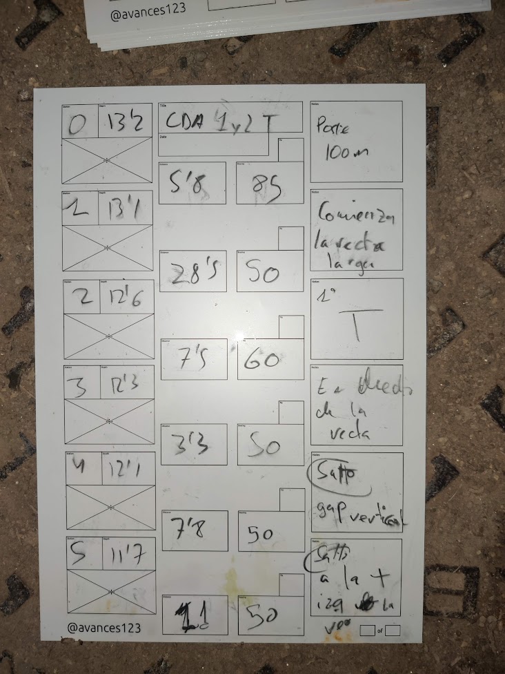
The topography has been carried out with an error precision of 0.1 meters in both length and depth and a margin of 5 degrees in the heading of measurements; the length of “jump” type lines is not included in the statistics.
Project Explanation
The project’s purpose lies in creating a topography specifically adapted for underwater navigation, focusing on divers and excluding details irrelevant to this practice. This model will solely and exclusively focus on the representation of the polygonal layout. While this might lack significance in terrestrial cave topography, it is crucial for diving, serving as a cardinal guide within the cave environment and physically perceivable by divers.
To date, the main polygonal line and its secondary branches have been delineated up to a depth of 200 meters. However, there are areas pending cartography, such as the farthest region from the Chara galleries and the closure of the sea circuit. Despite the exploration beyond these sections, the precision of the measurements made has not been optimal (with a margin of error in the order of decimeters). These less accurate measurements will not be disclosed until reaching the same level of precision as the rest, considering that the inherent complexities in wall measurements and the consistency of depth measurements are less relevant to the diving community.
The project’s development will continue with the same methodology but at a faster pace, thanks to the complete automation of the tracing up to the 850 reference point. Presenting this section at present is believed to be highly useful for students, instructors, and tourists making their initial immersion in the area, providing them with a clear vision of the path to follow within the cave without delving into details about walls or depths, aspects that, due to their complexity or constancy, are less essential for divers.
Current Topography
In the current topography field, an abundance of historical information such as drawings, photos, and old lines can create confusion for present-day divers. Therefore, the focus is on mapping only the lines installed as of the current date, providing a clear and precise representation. This approach will allow divers to have updated information for safer and more efficient navigation, maintaining the integrity of historical data for reference and analysis.
Data Integrity and Peer Review
The collected data has been processed using specialized software in topography, minimizing the complexity associated with loop closures and the systematic storage of acquired information. Furthermore, an open review mechanism has been enabled to encourage transparency and correction of potential errors. This approach has been implemented through a collaborative platform (Online Data), where any individual has the opportunity to cross-verify the data and, if necessary, suggest corrections through a ‘pull request.’ Since this data is available in an open-source format, it facilitates access and utilization by anyone interested in the field.

Global Statistics of the Entire Cave
This presentation offers a comprehensive statistical summary of the thread segment corresponding to Cueva del Agua up to a depth of 200 meters. Each data row encompasses a relevant topographic survey, usually associated with a gallery or relevant segment. It is worth noting that stations and segments classified as jumps are not considered in this statistic, reflected in multiple rows containing pure measurements of the cave’s dimensions, excluding such elements from analysis.
Title Length Depth Explored Approx. Duplicate Surface Shots Stations
Cueva_del_Agua 833 13 0 264 0 0 131 157
Las_Gemelas 164 11 0 0 0 0 21 27
gemelas1 68 8 0 0 0 0 9 10
gemelas2 13 4 0 0 0 0 1 2
gemelas3 31 6 0 0 0 0 3 4
galeria_soto 5 1 0 0 0 0 2 3
galeria_verde 17 5 0 0 0 0 4 5
union_gemelas 30 4 0 0 0 0 2 3
De_0_a_100 109 4 0 0 0 0 19 22
primeros_metros 46 2 0 0 0 0 7 8
stress 27 4 0 0 0 0 6 7
encajonada 37 1 0 0 0 0 6 7
Caverna 128 11 0 10 0 0 41 50
hilo_caverna 0 0.000000 0 0 0 0 7 8
caverna_gemelas 0 0.000000 0 0 0 0 2 3
buclecito 30 3 0 0 0 0 9 10
caverna_mar 10 0 0 10 0 0 5 6
moto 37 8 0 0 0 0 6 7
a_gemelas2 0 0.000000 0 0 0 0 3 4
restricciones_cartel 52 4 0 0 0 0 9 12
restriccion1 26 2 0 0 0 0 5 6
restriccion2 18 2 0 0 0 0 3 4
restriccion3 8 0 0 0 0 0 1 2
De_100_a_200 431 5 0 254 0 0 50 58
bucle 177 5 0 0 0 0 20 21
la_cruz 63 1 0 63 0 0 10 12
eje1 36 1 0 36 0 0 6 7
eje2 27 0 0 27 0 0 4 5
zig_zag1 76 0 0 76 0 0 7 8
ventana_larga 31 0 0 31 0 0 5 6
ventana_corta 17 0 0 17 0 0 3 4
chara1 22 0 0 22 0 0 2 3
chara2 45 0 0 45 0 0 3 4Future Improvements
The aim is to maintain the design’s simplicity, but the inclusion of symbols to represent restrictions, shafts, or chimneys of great importance on the map is under consideration.
A section dedicated exclusively to relevant articles will be established to ensure the permanent availability of the most updated and comprehensive topography.
Additionally, georeferencing on the surface orthophoto will be carried out, and a three-dimensional model will be generated to offer a more complete and precise spatial representation.